


Valmorel en Savoie Crève Tête

ARPF
User
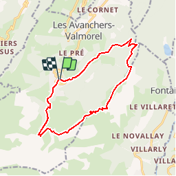

Length
13.5 km

Max alt
2323 m

Uphill gradient
1015 m
Km-Effort
27 km

Min alt
1344 m

Downhill gradient
1004 m
Boucle
Yes
Creation date :
2019-01-15 12:54:54.077
Updated on :
2019-01-15 12:54:54.077
5h30
Difficulty : Difficult

FREE GPS app for hiking
 SityTrail
IGN / Geographical institutes
SityTrail Plus
The world is yours!
About
Trail Walking of 13.5 km to be discovered at Auvergne-Rhône-Alpes, Savoy, Les Avanchers-Valmorel. This trail is proposed by ARPF.
Description
Partir de Valmorel pas loin de la piscine ;
puis montée vers le sommet de Crève Tête
Positioning
Country:
France
Region :
Auvergne-Rhône-Alpes
Department/Province :
Savoy
Municipality :
Les Avanchers-Valmorel
Location:
Unknown
Start:(Dec)
Start:(UTM)
300196 ; 5037330 (32T) N.
Comments